

























































For many Minnesotans, the idyllic promise of July is defined by clear blue skies, the scent of pine, and the shimmer of pristine lakes. This year, however, that seasonal tranquility has been abruptly punctured. After a deceptively calm start to the summer, the state’s atmosphere has turned opaque, clouded by the encroaching threat of wildfire smoke that is no longer just a visitor from across the border—it is now a domestic reality.
As of mid-July, the Minnesota landscape is grappling with a surge in active wildfires, including high-profile blazes within the Boundary Waters Canoe Area Wilderness (BWCAW). While Canadian forests have historically been the primary culprit for the haze that periodically chokes the Midwest, a recent confluence of extreme heat and lightning activity has ignited the northern border, signaling a potentially long and arduous fire season.
The Spark: A Chronology of the July Outbreak
The transition from a "spoiled" early summer—characterized by lower-than-normal temperatures and manageable humidity—to a crisis state was swift. The catalyst arrived in the form of a severe storm system that swept through northern Minnesota on July 6.
According to the Minnesota Incident Command System (MICS), the storm brought not just rain, but an intense barrage of lightning strikes across the dry timber of the Superior National Forest. Within days, these strikes sparked more than a dozen active wildfires. By Thursday, the situation had escalated significantly, with three of those fires burning deep within the iconic BWCAW.
The urgency of the situation forced immediate administrative action. On Tuesday, officials made the difficult decision to close the BWCAW to the public. At the time of the closure, an estimated 6,000 to 10,000 visitors were scattered throughout the wilderness. In a massive logistical undertaking, federal and state agencies scrambled to notify and evacuate campers. By Wednesday, authorities estimated they had successfully reached 90% of the individuals in the wilderness area, though the remoteness of the terrain continued to present significant challenges for ground crews and emergency personnel.
Supporting Data: An Unprecedented Trend
The current environmental instability is not an isolated event but rather the latest chapter in a broader, concerning trend. Over the past five years, the Minnesota Department of Health has tracked an alarming increase in the frequency and severity of air quality alerts linked directly to wildfire smoke.
Meteorologists like Matt Taraldsen of the Minnesota Pollution Control Agency (MPCA) have been tracking the intersection of climate patterns and fire risk for years. Earlier this summer, the MPCA noted that the lingering effects of the El Niño pattern were setting the stage for a prolonged, multi-state drought. This, combined with shifting atmospheric currents, has created a "perfect storm" for fire propagation.
The data supports a grim outlook. The Minnesota State Climatology Office, in its recent Climate Journal, characterized the summer of 2025 as the "Great American Smokeout," noting that the smoke is increasingly being driven by north and northwesterly winds pulling fire-laden air from the vast, drought-stricken forests of Manitoba and Saskatchewan. The National Institutes of Health (NIH) has pointed to 2023 as a "turning point" in this trajectory, noting that 46 million acres burned across North America, with smoke plumes reaching as far as Europe. For the residents of Minnesota, this is no longer a distant news story—it is a localized health crisis.
Official Responses and Tactical Challenges
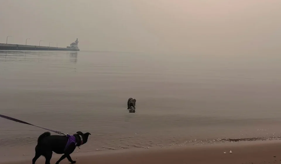
As the smoke settled over the metro area, central counties, and the Arrowhead region, the MPCA issued a widespread air quality alert effective through 11 a.m. Friday. The agency warned that the combination of heavy smoke and existing air pollution creates a potent cocktail that exacerbates respiratory conditions and cardiovascular health risks.
The tactical response to the current fires has been hampered by the very elements they seek to contain. Karen Harrison, a spokesperson for state and federal emergency management agencies, noted that the smoke density has severely limited the ability to deploy aerial assets. "Smoke is making it difficult for helicopters to fly," Harrison stated. "There will be fire on the landscape until fall, and some fire will be burning until snow cover."
This sentiment is echoed by regional partners. The Royal Canadian Air Force recently assisted in the high-stakes evacuation of 11 Minnesota teenagers and four staff members from a provincial park in Ontario, located roughly 175 miles north of the border. This international cooperation underscores the reality that fire does not respect national boundaries.
Despite the complexities of the current situation, the National Weather Service (NWS) maintains that its monitoring capabilities remain robust. Brennan Dettmann, a meteorologist at the NWS office in Chanhassen, confirmed that despite reports of federal budget constraints, their station remains fully staffed. Twice-daily weather balloon launches—at 6 a.m. and 6 p.m.—continue to provide critical data on atmospheric temperature, pressure, and humidity, allowing for the predictive modeling necessary to warn the public of incoming smoke.
A View from the Front Lines: Lessons from Flin Flon
To understand the broader context of the wildfire surge, one must look toward the Canadian mining town of Flin Flon, which straddles the Manitoba-Saskatchewan border. For residents there, fire is a constant neighbor.
Ron Dobson, a local journalist, describes a tenuous balance. "We’ve got rain and it’s more like a normal summer other than forest fires," Dobson said. "There are some fires more to the north, but if it gets really dry, then it could change."
The experience of Flin Flon serves as a cautionary tale for Minnesota. Last summer, the city was nearly decimated by fire, with nearby communities in Denari Beach seeing entire properties razed to the ground. The logistical nightmares faced by the town—where a single 100-kilometer road represents the only escape route—highlight the fragility of infrastructure in remote, fire-prone regions. The recent evacuation of Lynn Lake, Manitoba’s "sport fishing capital," serves as a stark reminder of how quickly a summer destination can become a disaster zone.
Implications: The New Normal
The situation in Minnesota is shifting from an episodic annoyance to a systemic challenge. For years, the state was buffered by its geography and climate, but the evidence suggests that the environment is undergoing a fundamental shift.
1. Public Health Vulnerability
The recurring need for air quality alerts necessitates a change in public behavior. As the MPCA and health officials continue to monitor particulate matter, citizens are being urged to limit strenuous outdoor activities during high-smoke events. The reliance on masks designed to filter fine airborne particles is becoming a seasonal expectation rather than an anomaly.
2. Economic Impact on Tourism
The Boundary Waters and the Arrowhead region are vital components of Minnesota’s tourism economy. The closure of the BWCAW, even for a short period, ripples through the local economy, affecting outfitters, hospitality providers, and travel-related businesses. With officials signaling that fire will be a permanent fixture on the landscape until winter, the uncertainty surrounding wilderness access may persist for the remainder of the season.
3. Increased Interagency Collaboration
The necessity for cross-border cooperation between the Minnesota Incident Command System, the U.S. Forest Service, and Canadian agencies like the Canadian Interagency Forest Fire Centre (CIFFC) has never been higher. As fires grow in scale, the sharing of meteorological data, firefighting resources, and evacuation intelligence will be the primary line of defense.
4. Climate Resiliency
The "turning point" cited by the NIH suggests that the current atmospheric conditions are likely to repeat. This requires long-term planning for forest management, the hardening of remote infrastructure, and a more resilient public health strategy. The equipment used by NWS meteorologists—the weather balloons that ascend 20 miles into the atmosphere to record the changing state of the air—is now more than just a tool for weather forecasting; it is a critical instrument for public safety.
Conclusion
As Minnesota moves deeper into the summer, the haze serves as a somber reminder of the changing climate. The fires in the Superior National Forest are not merely a temporary inconvenience; they are a manifestation of a broader, warming reality that requires vigilance, adaptation, and a renewed respect for the volatility of the northern wilderness.
For now, the sky remains the primary indicator of the days ahead. As the NWS and the MPCA continue their hourly data collection, the people of Minnesota remain in a state of watchful waiting, cognizant that in this new era of wildfire volatility, the clear, smoke-free days of the past are becoming an increasingly rare commodity.