
























































Powerful Magnitude 7.1 Earthquake Strikes Kumamoto, Japan: Shindo 7 Shaking Triggers Tsunami Advisories and Widespread Alerts

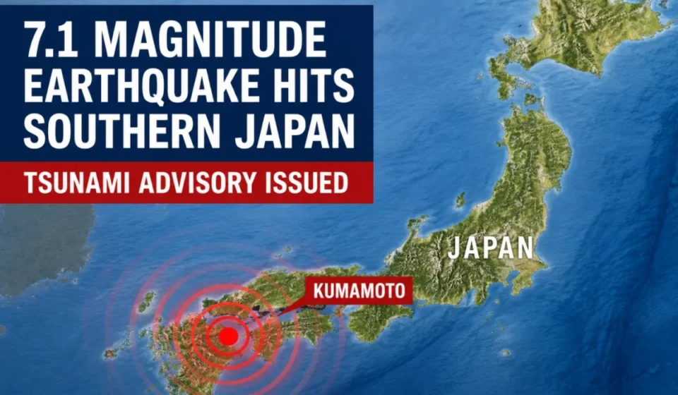
KUMAMOTO, JAPAN — A powerful magnitude 7.1 earthquake struck the southern island of Kyushu on the afternoon of Tuesday, July 28, 2026, registering the maximum possible intensity on Japan’s seismic scale. The violent tremor, which originated at a shallow depth in Kumamoto Prefecture, prompted immediate tsunami advisories for local semi-enclosed seas, triggered widespread automated emergency warnings across multiple prefectures, and forced residents to seek high ground amid fears of structural collapses and landslides.
The seismic event occurred at 4:27 p.m. local time. The Japan Meteorological Agency (JMA) localized the epicenter in the Kumamoto region at a depth of approximately 10 kilometers (6 miles). Due to the shallow nature of the rupture, the shaking felt at the surface was exceptionally violent, reaching Shindo 7—the absolute peak of Japan’s seismic intensity scale—in parts of Kumamoto Prefecture.
As emergency response teams deploy across Kyushu to assess the scale of the disaster, local authorities are urging the public to remain vigilant against strong aftershocks, potential landslides, and localized coastal flooding.
Chronology of the Event and Immediate Aftermath
[4:27 PM] --- M7.1 Earthquake strikes Kumamoto (10 km depth)
[4:28 PM] --- JMA issues instant Earthquake Early Warnings (EEW) across 7 prefectures
[4:30 PM] --- Tsunami Advisory issued for Ariake and Yatsushiro Seas (Up to 1m waves)
[4:35 PM] --- Bullet trains (Shinkansen) and regional transit automatically suspend operations
[4:45 PM] --- Emergency evacuation orders issued for low-lying coastal areas in Kumamoto
[5:15 PM] --- PTWC confirms no tsunami threat to Hawaii, American Samoa, or the wider Pacific
The Initial Shock and Rapid Warning Broadcasts
At 4:27 p.m. JST on July 28, 2026, the primary P-waves of the magnitude 7.1 earthquake tripped the JMA’s highly sensitive borehole seismometers. Within seconds, the system calculated the potential severity of the secondary S-waves and broadcasted automated Earthquake Early Warnings (EEW) to millions of mobile phones, television screens, and radio stations across southern Japan.
The immediate warning zone blanketed seven prefectures on the island of Kyushu:
- Kumamoto
- Nagasaki
- Kagoshima
- Fukuoka
- Saga
- Oita
- Miyazaki
As the violent shaking commenced, residents in Kumamoto reported intense vertical jolts followed by prolonged, violent horizontal swaying that made standing virtually impossible.
Evolution of the Tsunami Threat
By 4:30 p.m., just three minutes after the main shock, the JMA issued a Tsunami Advisory targeting the Ariake Sea and the Yatsushiro Sea—two critical, semi-enclosed bodies of water flanking the western coast of Kumamoto and neighboring Nagasaki and Saga prefectures. Oceanographic models estimated that waves could reach heights of up to 1 meter (3.3 feet).
Local municipal authorities immediately activated coastal sirens, instructing fishermen, port workers, and coastal residents to evacuate beaches and low-lying areas. Fortunately, by late afternoon, international monitoring bodies, including the Pacific Tsunami Warning Center (PTWC) in Hawaii, confirmed that the earthquake’s localized, inland-leaning epicentral location meant there was no broader tsunami threat to Hawaii, American Samoa, or other distant Pacific coastlines.
Supporting Data and Technical Specifications
To understand the severity of the July 28 earthquake, it is essential to analyze the scientific metrics provided by the JMA and collaborating global seismological networks.
Earthquake Parameters
| Parameter | Confirmed Scientific Data |
|---|---|
| Date of Event | July 28, 2026 |
| Origin Time | 16:27 JST (07:27 UTC) |
| Epicenter Location | Kumamoto Prefecture, Kyushu, Japan |
| Preliminary Magnitude | 7.1 ($M_j$ / $M_w$) |
| Hypocentral Depth | Approximately 10 kilometers (6.2 miles) |
| Maximum Seismic Intensity | Shindo 7 (Registered in Kumamoto Prefecture) |
| Primary Tsunami Risk Zones | Ariake Sea, Yatsushiro Sea |
| Estimated Wave Amplitude | Up to 1.0 meter (3.3 feet) |
Understanding the Shindo 7 Intensity Scale
While the moment magnitude ($M_w$) scale measures the total energy released by an earthquake at its source, Japan’s Shindo (seismic intensity) scale measures the actual ground motion and destructive effects at specific geographic points. The scale ranges from 0 to 7.
+-------------------------------------------------------------------------+
|                         THE JMA SHINDO SCALE                            |
+-------------------------------------------------------------------------+
| Shindo 5-Lower/Upper : Difficulty standing; unreinforced walls crack.   |
|                                                                         |
| Shindo 6-Lower/Upper : Impossible to stand; wood houses may tilt/collapse|
|                                                                         |
| Shindo 7             : Severe structural damage to modern buildings;    |
|                        ground cracks, landslides; utilities severed.   |
+-------------------------------------------------------------------------+
A Shindo 7 rating indicates catastrophic local shaking. Under these conditions:
- People are thrown to the ground and find it impossible to move voluntarily.
- Unreinforced concrete-block walls collapse, and even reinforced concrete buildings designed under older building codes can suffer severe structural failure or tilt.
- Most or all unsecured furniture moves violently, overturns, or becomes airborne.
- Gas, water, and electrical mains are severed over a wide area, and major ground fissures or slope failures occur.
The shallow depth of 10 kilometers amplified these effects. When a major earthquake occurs close to the Earth’s surface, the seismic energy has less distance to dissipate before reaching populated areas, resulting in far more violent localized acceleration than a deeper earthquake of the same magnitude.
Official Responses and Emergency Measures
Following the tremor, the Japanese government and regional administrative bodies mobilized their disaster response protocols.
National Government Action
In Tokyo, the Prime Minister’s Office immediately established an Emergency Response Task Force at the Crisis Management Center. Officials are coordinating directly with the Self-Defense Forces (SDF), the National Police Agency, and local fire departments to streamline search and rescue operations.
The JMA held an emergency press conference shortly after the quake. Representatives explained the mechanism of the strike-slip or thrust faulting typical of the region and reiterated the gravity of the tsunami advisory. "A one-meter tsunami must not be underestimated," a JMA spokesperson warned. "The force of a one-meter wave carrying ocean currents can easily sweep adults off their feet, inundate coastal roads, and wreck small vessels moored at harbors. Residents must remain on high ground until the advisory is officially lifted."
Regional Infrastructure and Transport Response
Kyushu’s highly integrated transportation networks triggered automated safety shutdowns immediately:
- High-Speed Rail: Kyushu Shinkansen (bullet train) operations between Hakata (Fukuoka) and Kagoshima-Chuo were automatically suspended as power-cut safety systems detected the primary seismic waves.
- Expressways: Major arterial highways across Kumamoto, Miyazaki, and Kagoshima were closed to civilian traffic to allow structural engineers to inspect overpasses and pavement integrity for cracks or liquefaction.
- Aviation: Runways at Kumamoto Airport (KMJ) and nearby regional airports were temporarily closed for visual inspections to ensure no buckled asphalt would endanger landing aircraft.
Nuclear Power Plant Inspections
A primary concern during any major Japanese earthquake is the safety of regional nuclear facilities. Kyushu Electric Power quickly conducted emergency diagnostics at its nuclear facilities:
- The Sendai Nuclear Power Plant (located in Satsumasendai, Kagoshima Prefecture) reported no immediate abnormalities, and reactors continued to operate safely or remained in their designated stable states.
- The Genkai Nuclear Power Plant (in Saga Prefecture) also reported no seismic damage or disruptions to its cooling systems.
Implications, Risks, and Historical Context
The psychological and structural implications of this earthquake are profound, particularly given Kumamoto’s history.
The Shadow of the 2016 Kumamoto Earthquakes
For the residents of Kyushu, this event evokes painful memories of the April 2016 Kumamoto earthquakes. A decade prior, the region was battered by a complex, highly destructive double-earthquake sequence:
- On April 14, 2016, a foreshock of magnitude 6.5 struck Kumamoto, registering Shindo 7.
- Just 28 hours later, on April 16, 2016, a larger magnitude 7.3 mainshock struck the same fault zone, also registering Shindo 7.
The 2016 disaster claimed over 200 lives, injured thousands, caused widespread landslides in mountainous areas like Minamiaso, and severely damaged historic landmarks, including Kumamoto Castle.
               COMPARISON OF HISTORIC KUMAMOTO SEISMIC EVENTS

   2016 Sequence                             2026 Event
   +-----------------------+                 +-----------------------+
   | Foreshock: M6.5       |                 | Main Shock: M7.1      |
   | Mainshock: M7.3       |                 | Depth: 10 km          |
   | Max Shindo: 7 (Twice) |                 | Max Shindo: 7         |
   | Severe Landslides     |                 | Tsunami Advisory: Yes |
   +-----------------------+                 +-----------------------+
The JMA has pointed out that the July 28, 2026, earthquake shares a similarly shallow depth and magnitude with the 2016 mainshock. Seismologists warn that because the region is crisscrossed by active fault segments (such as the Futagawa and Hinagu fault zones), the current M7.1 event could trigger adjacent fault lines, potentially leading to strong, prolonged aftershock activity or even a subsequent, larger seismic event.
Secondary Hazard Vulnerabilities
As night falls on Kyushu, emergency planners are focusing on three critical secondary hazards:
1. Mountainous Landslides and Slope Failures
Kumamoto’s volcanic topography, heavily influenced by Mount Aso, features steep slopes covered in loose soils. Violent Shindo 7 shaking can destabilize these hillsides. If subsequent rainfall occurs, weakened slopes could give way, threatening rural valleys and blocking critical evacuation routes.
2. Aftershocks in Compromised Structures
Structures that survived the initial M7.1 shock may have suffered quiet, internal structural degradation. Subsequent aftershocks of magnitude 5.0 or 6.0—which are highly probable in the coming days—could easily bring down partially compromised homes, commercial buildings, and historical stone walls.
3. Soil Liquefaction
In low-lying coastal zones and reclaimed land near the Ariake and Yatsushiro seas, the intense shaking can cause water-saturated, loose soil to temporarily lose its strength and behave like a liquid. This process, known as liquefaction, can cause buildings to sink, tilt, or suffer major foundation failures, while also rupturing underground water and sewage networks.
Guidelines for Local Residents
Disaster management officials have issued immediate, actionable advice for those currently in the affected areas:
- Respect the Coastal Advisories: Do not return to coastal areas to inspect boats or view the shoreline. Even if the ocean appears calm, tsunami waves can cycle over several hours, with later waves often arriving with greater volume and velocity than the first.
- Conduct Indoor Hazard Checks: If indoors, wear thick-soled shoes to protect against shattered glass, porcelain, and fallen light fixtures.
- Prevent Post-Quake Fires: In the event of a power outage, unplug major electrical appliances. This prevents "re-ignition fires" from occurring when grid power is suddenly restored to damaged electrical lines or heaters.
- Beware of Misinformation: During active disasters, unverified claims, false predictions, and alarmist rumors often spread rapidly on social media. Residents are strongly urged to rely solely on official broadcasts from the JMA, NHK, and local municipal emergency offices.
As emergency crews work through the night to clear debris and re-establish communications with isolated mountain villages, the full extent of the physical and economic damage from this powerful earthquake will become clearer. For now, Kyushu remains on high alert, braced for the volatile aftershocks that invariably follow a Shindo 7 event.