





















































Powerful Magnitude 7.1 Earthquake Strikes Kumamoto, Triggering Shindo 7 Shaking and Tsunami Advisories

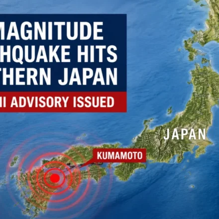
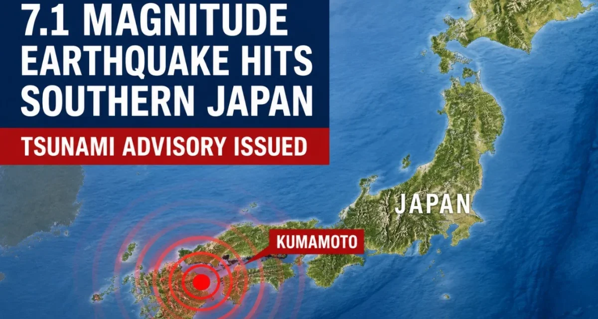
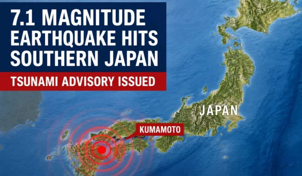
KUMAMOTO, JAPAN — A powerful magnitude 7.1 earthquake struck the southwestern Japanese island of Kyushu on Tuesday afternoon, July 28, 2026, triggering the highest possible level of shaking on the nation’s seismic intensity scale. The violent tremor prompted immediate tsunami advisories for local semi-enclosed seas and initiated a massive emergency response across multiple prefectures.
The earthquake, which struck at 4:27 p.m. local time, was centered in Kumamoto Prefecture at a shallow depth of approximately 10 kilometers (6 miles). The shallow nature of the rupture amplified the ground motion, resulting in a maximum seismic intensity of Shindo 7—the peak rating on the Japan Meteorological Agency (JMA) scale—in Kumamoto.
I. Main Facts: Severe Shaking and Immediate Coastal Threats
The seismic event triggered automatic emergency broadcasting systems across southwestern Japan. Because the earthquake occurred at a very shallow depth, the energy released was felt with extreme violence near the epicenter.
+------------------------+--------------------------------------------------+
| Detail                 | Latest Confirmed Information                     |
+------------------------+--------------------------------------------------+
| Date                   | July 28, 2026                                    |
| Time                   | 4:27 p.m. local time                             |
| Location               | Kumamoto Prefecture, Kyushu, Japan               |
| Preliminary Magnitude  | 7.1 (Japan Meteorological Agency)                |
| Focal Depth            | Approximately 10 kilometers (6 miles)            |
| Maximum Shaking        | Shindo 7 (Highest level on JMA scale)            |
| Tsunami Advisories     | Ariake Sea and Yatsushiro Sea                    |
| Expected Wave Height   | Up to 1 meter (3.3 feet)                         |
+------------------------+--------------------------------------------------+
Immediately following the main shock, the JMA issued tsunami advisories for the Ariake Sea and the Yatsushiro Sea, two highly sheltered coastal bodies of water bordering Kumamoto, Nagasaki, and Saga prefectures. Coastal residents were ordered to evacuate low-lying areas immediately and seek higher ground. Meanwhile, emergency earthquake warnings flashed across mobile networks, television screens, and radio stations in seven prefectures: Kumamoto, Nagasaki, Kagoshima, Fukuoka, Saga, Oita, and Miyazaki.
II. Chronology of Events: From Initial Tremor to Emergency Mobilization
The timeline of the disaster highlights the rapid sequence of events and the immediate mobilization of Japan’s highly sophisticated early-warning infrastructure.
4:27 p.m. — The Main Shock
The earth ruptured along a local fault line in Kumamoto Prefecture. Within seconds, the JMA’s Earthquake Early Warning (EEW) system detected the primary waves (P-waves) and calculated a high-intensity event, automatically broadcasting loud alarms to millions of smartphones, television networks, and public speaker systems across Kyushu.
4:28 p.m. — Shaking Reaches Peak Intensity
The destructive secondary waves (S-waves) rippled outward from the epicenter. In central Kumamoto, the shaking escalated rapidly, reaching Shindo 7. Ground acceleration was severe enough to throw unsecured objects into the air, halt trains, and cause immediate structural failures in older, wooden buildings.
4:31 p.m. — Tsunami Advisories Issued
Following rapid assessment of the earthquake’s marine displacement potential, the JMA issued official tsunami advisories for the Ariake Sea and Yatsushiro Sea. Wave heights of up to 1 meter (3.3 feet) were projected. Local municipal authorities immediately activated coastal sirens, instructing residents to flee beaches, ports, and river estuaries.
4:45 p.m. — Government Task Force Established
In Tokyo, the Prime Minister’s Office activated its Crisis Management Center, establishing an official disaster response task force. Emergency reconnaissance teams, including police, fire departments, and Self-Defense Forces (SDF) units, were ordered to prepare for deployment to Kumamoto.
5:00 p.m. — Infrastructure Status Reports
Major utility companies and transport operators began reporting system disruptions. High-speed Shinkansen bullet train services across Kyushu were automatically suspended due to power cuts and track safety sensors. Inspections began at regional nuclear facilities to ensure reactor safety.
III. Supporting Seismic and Tsunami Data
To understand the severity of this event, it is necessary to examine the specific scientific metrics used by Japanese authorities to evaluate earthquakes and marine hazards.
Understanding the Shindo 7 Rating
While the Richter scale and moment magnitude scale ($M_w$) measure the total energy released at the earthquake’s source, Japan’s Shindo (seismic intensity) scale measures the actual ground motion experienced at specific geographic points.
Shindo Scale (0 to 7)
[0] -> [1] -> [2] -> [3] -> [4] -> [5 Lower] -> [5 Upper] -> [6 Lower] -> [6 Upper] -> [7]
                                                                                      ^
                                                                           Current Kumamoto Quake
Shindo 7 is the absolute maximum on this scale. It represents catastrophic ground acceleration where:
- People find it impossible to remain standing or move willfully; they may be thrown violently through the air.
- Unreinforced concrete-block walls collapse, and even reinforced concrete structures can suffer severe tilting or structural failure.
- Landslides occur on vulnerable slopes, gas and water mains rupture, and electrical grids suffer widespread physical damage.
The Mechanics of a Shallow Depth
The focal depth of 10 kilometers is classified as "very shallow." In seismology, shallow crustal earthquakes are notoriously destructive. Because the seismic energy has to travel only a short distance to reach the surface, there is minimal attenuation (loss of energy) before the seismic waves hit populated areas.
The Danger of a 1-Meter Tsunami
To the general public, a "one-meter tsunami" may sound minor, but oceanographers emphasize that a tsunami behaves differently from a wind-driven wave. A tsunami is a massive wall of water moving at speeds of up to several hundred miles per hour.
A one-meter-high tsunami carries immense kinetic energy and can easily sweep adults off their feet, inundate coastal roads, crush small vessels against harbor docks, and carry debris inland, creating additional hazards. The semi-enclosed geography of the Ariake and Yatsushiro Seas can also amplify wave heights through a phenomenon known as seiche, where water sloshes back and forth in a confined basin.
IV. Official Responses and Infrastructure Assessments
Following the disaster, Japanese officials implemented standardized emergency protocols to secure vital infrastructure and safeguard public health.
Nuclear Power Plant Status
A primary concern during any major seismic event in Japan is the integrity of its nuclear power stations. Kyushu hosts several facilities, most notably:
- The Sendai Nuclear Power Plant (Kagoshima Prefecture)
- The Genkai Nuclear Power Plant (Saga Prefecture)
Operators of both facilities reported that reactors continued to operate safely without immediate signs of damage or radiation leaks. Automatic safety systems did not trigger emergency shutdowns, though engineers initiated comprehensive physical inspections of all reactor buildings, cooling systems, and spent fuel pools.
Transportation and Utilities
The Kyushu Shinkansen line suspended all operations between Hakata and Kagoshima-Chuo stations to allow track maintenance crews to inspect the line for structural deformation or electrical mast damage.
Local highway operators closed several expressways across Kumamoto and Nagasaki to assess pavement cracks and potential slope failures. Power grid operators reported localized blackouts affecting thousands of homes, primarily due to downed distribution lines and tripped safety transformers.
Search and Rescue Operations
Local police and fire departments mobilized search and rescue teams to check on vulnerable communities, particularly elderly residents living in older wooden structures. The Japanese government urged citizens to remain vigilant, wear thick-soled shoes to protect against shattered glass, and immediately shut off gas valves to prevent secondary post-earthquake fires.
V. Historical Parallel: The Shadow of the 2016 Kumamoto Disasters
For the residents of Kyushu, this latest earthquake evokes painful memories of the devastating 2016 Kumamoto earthquakes.
+-----------------------------------------------------------------------------+
|                     KUMAMOTO SEISMIC HISTORY COMPARISON                     |
+-----------------------------------------------------------------------------+
| 2016 Sequence:                                                              |
|   - April 14, 2016: M6.5 Foreshock (Shindo 7)                               |
|   - April 16, 2016: M7.3 Mainshock (Shindo 7)                               |
|   - Toll: Over 200 fatalities, extensive damage to Kumamoto Castle.         |
+-----------------------------------------------------------------------------+
| 2026 Event:                                                                 |
|   - July 28, 2026: M7.1 Earthquake (Shindo 7)                               |
|   - Tsunami advisories issued; region-wide aftershock warnings active.      |
+-----------------------------------------------------------------------------+
In April 2016, a highly unusual double-shock sequence struck the same region. A magnitude 6.5 earthquake on April 14 was initially believed to be the main event. However, roughly 28 hours later, a much larger magnitude 7.3 earthquake struck, causing widespread destruction, collapsing bridges, triggering massive landslides in Minamiaso, and severely damaging the historic Kumamoto Castle.
The 2016 disaster proved that a major earthquake can be a precursor to an even larger event. Seismologists at the JMA are using this historical precedent to caution the public against complacency. While the magnitude 7.1 earthquake on July 28, 2026, is currently treated as the main event, the possibility of strong, potentially larger aftershocks remains a critical concern for the coming days.
VI. Broader Implications and Ongoing Preparedness
This earthquake serves as a stark reminder of Japan’s constant struggle against tectonic forces. Located at the intersection of four major tectonic plates—the Pacific, Philippine Sea, Eurasian, and North American plates—the Japanese archipelago is one of the most seismically active regions in the world.
Structural Resilience and Modern Building Codes
Since the 1995 Great Hanshin Earthquake in Kobe, Japan has continuously updated its building codes, enforcing some of the strictest seismic resistance standards globally. Buildings constructed after 1981 (under the Shin-耐震 or New Seismic Design Standard) and further updated in 2000 are designed to sway rather than collapse during Shindo 6 or 7 tremors.
While these modern engineering practices significantly reduce casualties, older homes, historic temples, and municipal infrastructure remain vulnerable to shallow, high-intensity shaking.
Combatting Online Misinformation
In the immediate aftermath of major natural disasters, false claims and fabricated predictions often circulate on social media platforms. Seismologists stress that it is scientifically impossible to predict the exact date, time, and magnitude of an earthquake.
Emergency management officials urge the public to ignore viral rumors and rely exclusively on official broadcasts from the JMA, local municipalities, and verified news outlets.
Crucial Safety Guidelines for Residents
As emergency teams continue their assessments, local authorities have issued a list of critical safety instructions for those in the affected zones:
- Evacuate Coastal Zones: Do not return to beaches or low-lying areas until tsunami advisories are officially lifted, even if the ocean appears calm.
- Prepare for Aftershocks: Expect frequent aftershocks. Avoid standing near damaged concrete walls, steep slopes, or unstable buildings.
- Prevent Fires: Keep electrical appliances unplugged during power outages to prevent "restoration fires" when power is restored.
- Conserve Water: Use stored water supplies wisely, as underground water mains may have suffered quiet ruptures that will take days to locate and repair.
The full extent of the physical and economic damage from this magnitude 7.1 earthquake will take time to clarify. However, Japan’s robust early warning systems, strict building regulations, and disciplined public response remain the country’s best defense against the unpredictable forces of nature.